
|
Aggregate Polygons |
Combines polygons within a specified distance of each other into new polygons.
- This tool is intended for moderate scale reduction and aggregation when input features can no longer be represented individually due to the limited map space or the required data resolution. Aggregation will only happen where two polygon boundaries are within the specified aggregation distance to each other. There will be no self-aggregation, meaning no aggregation within an input polygon feature itself along its boundary, and no aggregation between any parts of a multipart polygon feature.
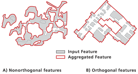
- Using the orthogonal option will construct orthogonally shaped output features. This option is best suited for use with input features that have predominantly orthogonal edges. In some cases, less aggregation will occur in order to accommodate this. For example, two square buildings situated diagonally apart within the aggregation distance may not be aggregated because there is no clear connection that can be made while preserving orthogonality. The nonorthogonal option will produce more organically shaped results.
- Use barrier features to prevent aggregation from occurring across boundaries. Examples include preventing land cover from aggregating across rivers or buildings aggregating across streets. Barriers can be either lines or polygons, and multiple barrier feature classes can be used simultaneously.
- If the input feature class is a layer referencing a representation, and there are shape overrides on any of the input features, the shape overrides will be assessed in the aggregation, not the feature geometry.
- The output feature class will not contain any geographic attributes from the input features. A one-to-many relationship table can be optionally created to link the aggregated polygons to their source polygons. This link can become incorrect when any of the input or output features are modified.
- If the input features contain Z values, the Z values can be preserved if specified in the environment settings. Where the output vertices are not changed, the input Z values will be carried over to the output vertices; otherwise, a Z value will be derived for new vertices, either from existing Z values or through interpolation.
- Processing a large input dataset may exceed memory limitations. In this case, consider processing input data by partition by identifying a relevant polygon feature class in the Cartographic Partitions environment setting. Portions of the data, defined by partition boundaries, will be processed sequentially. The resulting output feature class consistent at partition edges, but output features crossing partitions, will be split at the partition line. A field called IS_SPLIT in the output feature class will have a value of 1 in this instance.
Viz také:http://desktop.arcgis.com/en/desktop/latest/tools/cartography-toolbox/aggregate-polygons.htm


23.12.2016 11:21:23