|
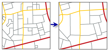
Thin Road Network |
Generates a simplified road network that retains connectivity and general character for display at a smaller scale.
This tool does not generate new output. It assigns values in Invisibility Field in the input feature classes to identify features that are extraneous and can be removed from view to result in a simplified, yet representative, collection of roads. No feature geometry is altered or deleted.
Features are not actually deleted by Thin Road Network. To actually remove features, consider using the Trim Line tool.
The resulting simplified road collection is determined by feature significance, importance, and density. Segments that participate in very long itineraries across the extent of the data are more significant than those required only for local travel. Road classification, or importance, is specified by the Hierarchy Field parameter. The density of the resulting street network is determined by the Minimum Length parameter, which corresponds to the shortest segment that is visually sensible to show at scale.
- The invisibility field must be present and named the same for all input feature classes. Features that should remain visible are assigned a value of 0; those that should be removed from the display are assigned a value of 1. Use a layer definition query or a selection to display the resulting simplified collection (for example, invisibility <> 1). You can use multiple invisibility fields to store different results—corresponding to different output scales—on the same feature class.
- The hierarchy field identifies the relative importance of features to help establish which features are significant. Hierarchy value 1 indicates the most important features with importance decreasing as hierarchy value increases. For optimal results, use no more than five levels of hierarchy. Input roads with Hierarchy = 0 are considered "locked" and will remain visible, along with adjacent roads necessary for connectivity. The hierarchy field must be present and named the same for all input feature classes.
- The hierarchy is typically derived from a field that specifies road classification and corresponds to the way that roads are symbolized. It is not related to the concept of hierarchy used in network analysis. Hierarchy values equal to NULL are not accepted by the tool and will raise an error.
- The Minimum Length parameter defines a sense of the resolution or granularity of the resulting simplified road collection. It should correspond to a length that is visually significant to include at the final scale. The results of this tool are a balanced compromise between the requirements posed by hierarchy, visibility locking, resolution, and morphology and connectivity of the road geometry. Therefore, the minimum length value cannot necessarily be measured directly in the resulting feature set.
- Processing large road datasets or a number of datasets together may exceed memory limitations. In this case, consider processing input data by partition by identifying a relevant polygon feature class in the Cartographic Partitions environment setting. Portions of the data, defined by partition boundaries, will be processed sequentially. The resulting feature class(es) will be seamless and consistent at partition edges. See How Thin Road Network works for more information about running this tool with partitioning.
- The integrity of the results of this tool relies on the topological integrity of the inputs. Proper connections must exist at intersections to faithfully represent the connectivity of the road network. See How Thin Road Network works for more information about data requirements and other helpful tips.
- If the inputs include a feature layer pointing to a representation, any geometry overrides associated with that representation will be used as the input geometry to determine the morphology and connectivity of the road collection. Similarly, representation visibility overrides will be honored, ensuring that invisible representations are not included in the resulting road collection and that adjacent roads are handled accordingly to maintain connectivity.
Viz také:http://desktop.arcgis.com/en/arcmap/10.3/tools/cartography-toolbox/thin-road-network.htm