|
Collapse Dual Lines To Centerline |
Combines polygons within a specified distance of each other into new polygons.
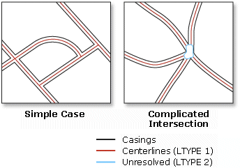
This tool is intended for regular, near parallel pairs of lines, such as large-scale road casings. Centerlines will be created only between open-ended lines not inside closed lines which are likely street blocks. The tool is not intended to simplify multiple-lane highways with interchanges, ramps, overpasses and underpasses, or railways with multiple, merging tracks. Use the Merge Divided Roads tool instead.
This tool cannot be executed within an edit session.
The output feature class will not carry the geographic attributes from the input lines, but contain the following three new fields:
- LnType—Contains the following line type values:
- Value of 1 for derived centerlines
- Value of 2 for outlines around relatively complicated intersections where centerlines are not generated, lines representing roads with a width beyond the specified range, and other broken or unpaired lines.
- Value of 3 for lines with unclear source casings (they usually connect two closely located intersections which may belong to one large intersection in reality.)
LeftLn_FID—Carries the object ID of the input line to the left of a derived centerline. This field value will be zero for lines of LnType 2 and 3.
RightLn_FID—Carries the object ID of the input line to the right of a derived centerline. This field value will be zero for lines of LnType 2 and 3.
You can use the LnType values to further inspect the unresolved intersections and wider roads; and you can use the LeftLn_FID and RightLn_FID fields along with Join Field tool to transfer the attributes from source lines to the centerlines as needed.